

GREEN CITIES SERIES | ARTICLE 19
Adelaide is the driest capital city in the driest inhabited continent on Earth, and it has known this about itself for long enough to have developed some genuinely instructive responses. Its investment in recycled water infrastructure, its early and serious engagement with urban heat as a public health emergency, and its stewardship of one of the great metropolitan parkland systems in the Southern Hemisphere all represent hard-won lessons rather than inherited advantages. Whether those lessons are being applied at the speed and scale that a warming Mediterranean climate demands is a more complicated question — and one the city is still in the process of honestly answering.
On a January morning in the Botanic Garden of Adelaide, before the day has had time to become dangerous, the air under the Moreton Bay figs is already doing something that the surrounding city will struggle to replicate for the next eight hours. It is cool here — not the cool of air conditioning, with its hermetic seal against the outside world, but the cool of water transpiring from ten thousand leaves, of root systems drawing moisture from deep beneath the path, of a canopy so dense that the light arrives in fragments. A pair of rosellas work the upper branches of a Canary Island date palm. An older man reads a newspaper on a bench worn smooth by a century of use. The temperature under the figs is, at this moment, perhaps six degrees lower than on the pavement of North Terrace fifty metres away.
By afternoon, North Terrace itself will approach forty degrees. Adelaide holds the distinction — not one it advertises — of recording more days above forty degrees Celsius than any other Australian capital city.1 Its Mediterranean climate, which gives it the long warm summers and mild winters that its boosters rightly celebrate, also gives it a heat profile that is becoming, under climate change, increasingly difficult to manage. The city sits in a bowl between the Mount Lofty Ranges to the east and the Gulf St Vincent to the west, and when a northerly wind delivers the interior heat of the continent to its streets, the physiological stress on its human and non-human population is acute and immediate.
The Botanic Garden is not a solution to this problem. It is 51 hectares of exceptional green infrastructure in a metropolitan area of 830 square kilometres. But it is also an argument — an argument that has been made consistently in this city for a hundred and eighty years, since Colonel William Light designed its famous parkland belt — that greenery and water are not luxuries in a city with Adelaide’s climate. They are the conditions of habitability. The question that the rest of this article tries to answer is whether Adelaide has made that argument, which it has understood in principle for generations, into something that works at the scale the climate now demands.
Light’s Vision: The Parkland City
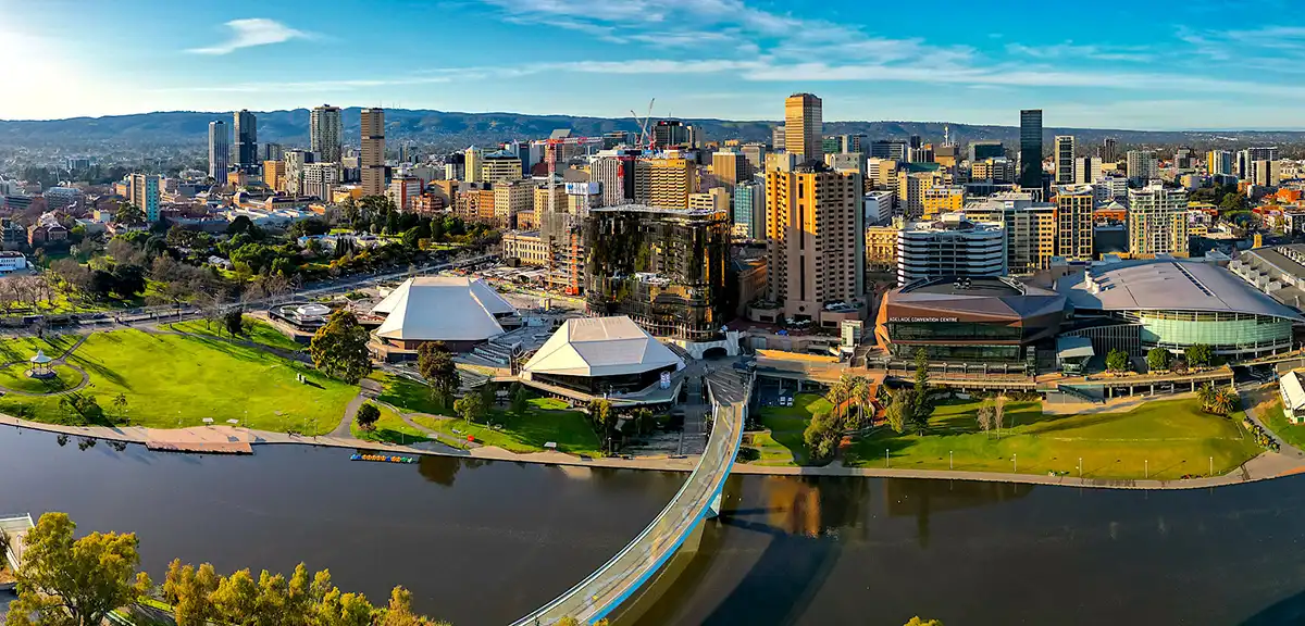
Colonel William Light’s 1837 plan for Adelaide is, among the designed capitals of the colonial world, one of the most ecologically prescient. Light laid out a formal grid for the city centre — one square mile of residential and commercial lots — and then surrounded it on all sides with a continuous belt of public parkland, roughly 700 hectares of open space forming an unbroken green collar between the city proper and the inner suburbs.2 The parklands were not, in Light’s original conception, primarily ecological infrastructure. They were open ground reserved from private development, available for public recreation, and serving as a firebreak and buffer between the urban core and its surrounds. Light did not need to be a climate scientist to understand that a city built in a semi-arid Mediterranean environment, with long hot summers and unreliable rainfall, required green space at a scale that the market would not provide without reservation.
Light’s parklands survived, imperfectly and incompletely, into the present. They have been nibbled by sporting facilities, car parks, road widening schemes, and the institutional expansion of the hospitals and universities that now line their edges. The proportion of the original reservation that remains as genuine open green space — as opposed to turfed sports grounds, hardstand car parks, or built infrastructure — has declined.3 But the skeleton of Light’s vision is intact: a continuous green belt encircling the central city, unique among Australian capitals and among very few planned cities worldwide, that moderates the urban heat island in the central area, provides ecosystem services of genuine value, and gives the central city a relationship with green space that its residents can access on foot. In the context of this series, it is worth noting that Light achieved this not by retrofitting green infrastructure into an already-built city — the challenge that confronts Melbourne, Barcelona, and Milan — but by reserving it before the city was built. The lesson is simple and largely ignored by contemporary urban planning: it is immeasurably cheaper and ecologically more effective to protect green space before development than to purchase or recover it afterwards.
The Kaurna people, the traditional custodians of the Adelaide Plains and the Mount Lofty Ranges, had managed this landscape for at least 40,000 years before European settlement, using fire, seasonal movement, and ecological knowledge to maintain the country’s productivity and biodiversity.4 The grasslands and open woodlands of the Adelaide Plains that Light encountered — the landscape that made his military assessment of the site so favourable — were in large part a cultural artefact: shaped by millennia of Kaurna burning practices that maintained the open, navigable character of the plain and supported the game, tubers, and seasonal resources on which Kaurna communities depended. The city that was built over this landscape in 189 years replaced a managed ecological system of great sophistication with a built environment that is only now beginning to recover some of the ecological functions it destroyed.
The River Torrens — the Karrawirra Pari of the Kaurna, the watercourse that runs east-west through the northern parklands from the Mount Lofty Ranges to the Gulf — was, for most of Adelaide’s European history, a degraded urban drain: its banks cleared, its flow regulated, its water quality devastated by urban runoff and the effluent of the industries that used it as a convenient disposal route. The rehabilitation of the Torrens over the past three decades — improved water quality, revegetated banks, platypus populations returning to sections of the upper reaches — is one of Adelaide’s more tangible environmental achievements, and the linear park that now follows the river through the city centre is the most visited green space in the metropolitan area.
The Murray’s Reckoning: Water in an Arid Capital
Adelaide’s water supply history is a study in the compounding consequences of building a large city in an environment that cannot, by itself, sustain one. The city draws the majority of its water from the Murray-Darling Basin — the vast river system draining the southeastern interior of the continent — via a pipeline system that delivers Murray River water to the city’s treatment plants.5 The Murray is already the most contested and environmentally stressed river system in Australia: its water is allocated among four states and the Australian Capital Territory, its flows have been progressively reduced by upstream irrigation extraction over more than a century, and its ecology — including the iconic Murray cod and the river red gum forests of its floodplain — has been severely degraded by low flows, blue-green algal blooms, and the accumulation of agricultural salts.
The Millennium Drought of the late 1990s and 2000s brought Adelaide’s water vulnerability into sharp public focus. At the drought’s peak, in 2007 and 2008, the Murray’s flow at the South Australian border fell to levels that threatened the city’s supply reliability and produced a salinity spike in the lower river that exceeded safe drinking water standards.6 The state government’s response was the most comprehensive water policy overhaul in South Australia’s history: a Water for Good plan adopted in 2009 that set targets for stormwater harvesting, recycled water use, rainwater tank installation, and demand management, and that has shaped Adelaide’s water strategy ever since.
The centrepiece of the strategy, and the investment that most clearly distinguishes Adelaide from its Australian peer cities, is the Adelaide Desalination Plant at Port Stanvac on the southern coast — a reverse osmosis facility completed in 2012 with a capacity of 100 gigalitres per year, capable of supplying up to fifty percent of Adelaide’s water needs from seawater.7 Like Melbourne’s equivalent plant at Wonthaggi, the Adelaide desalination facility has been operated at variable output depending on rainfall and reservoir levels, and its contract costs have attracted political controversy. Unlike Melbourne’s facility, it has a record of being called into active production during dry years — most recently during the 2018–2020 dry period — that gives its existence a practical justification its critics have found harder to dismiss.
But the investment that deserves more attention, because it is more instructive for other cities facing similar constraints, is Adelaide’s recycled water programme. SA Water — the state-owned water utility — has developed one of the most sophisticated recycled water networks in Australia, supplying treated wastewater to households, businesses, parks, and sports grounds across the metropolitan area for non-potable uses including garden irrigation, toilet flushing, and the watering of public green spaces.8 The Purple Pipe network — named for the distinctive purple colour coding of recycled water infrastructure — supplies recycled water to approximately 20,000 properties in areas including Mawson Lakes, the Barossa Valley, and the Virginia horticultural district north of the city. The Virginia scheme, which supplies recycled water for market garden irrigation, has been operating since the 1990s and has become one of the longest-running examples of large-scale agricultural recycled water use in the Southern Hemisphere.
Stormwater harvesting represents a further frontier of Adelaide’s water resource diversification. The Salisbury wetland and aquifer storage and recovery (ASR) system in the northern suburbs — developed from the 1990s through a collaboration between the City of Salisbury, SA Water, and the state government — captures stormwater runoff from the Dry Creek catchment in a series of constructed wetlands, treats it through natural filtration processes, and injects it into the local aquifer for recovery during dry periods.9 The system now harvests more than ten gigalitres per year that would otherwise flow to sea, providing water security for the northern suburbs’ parks and sports grounds and demonstrating at commercial scale that urban stormwater is a resource rather than a waste stream. The Salisbury model has been studied by water agencies across Australia and internationally, and its core principles have been replicated in varying forms in Perth, Melbourne, and in European cities confronting comparable stormwater capture challenges.
The Heat That Kills: Adelaide’s Most Urgent Environmental Challenge
Adelaide’s heat history is longer and more lethal than its general reputation acknowledges. The January 1939 heatwave — thirteen consecutive days above 38 degrees, culminating in a temperature of 46.1 degrees on Black Friday — killed at least 400 people across South Australia and preceded the bushfires that incinerated several towns in the Adelaide Hills.10 The January 2009 event — which preceded Melbourne’s Black Saturday by two days, with Adelaide recording 45.7 degrees on 28 January — produced similar conditions and a death toll that South Australia’s Coroner’s Office estimated at 374 people above the seasonal baseline, overwhelmingly among the elderly and those in inadequate housing without air conditioning.
The 2009 toll was the subject of a detailed coronial investigation whose findings shaped South Australia’s subsequent heat health response. The Coroner found that the majority of deaths occurred in private residences, among people living alone, in circumstances where a combination of inadequate housing thermal performance, absence of air conditioning, social isolation, and failure of the welfare check systems that were supposed to identify vulnerable people had combined to produce preventable deaths at scale.11 The report’s recommendations led directly to the development of South Australia’s Extreme Heat Framework — a tiered response system that, when temperatures are forecast to exceed thresholds associated with health risk, activates welfare checks, cooling centres, extended services for the elderly and vulnerable, and public communications about heat risk and protective behaviour.
The Extreme Heat Framework has been progressively refined since its introduction and is now regarded by public health researchers as among the better-designed heat health response systems in Australia.12 Its activation thresholds are based on epidemiological analysis of the temperature-mortality relationship in Adelaide’s specific population — acknowledging that acclimatisation means the mortality risk associated with a given temperature is not constant across seasons or across cities — and its welfare check protocols have expanded the number of vulnerable people reached during heat events. The framework is, in the language of public health, an effective short-term intervention. It is also, in the language of environmental planning, an emergency response to a failure of built environment that should have been addressed differently a generation ago.
Adelaide’s urban heat island is less severe than Melbourne’s or Sydney’s in its absolute magnitude — the smaller city footprint and the proximity of the Gulf and the Mount Lofty Ranges introduce moderating influences that larger inland urban areas lack — but its effect is still significant, adding two to four degrees to the regional temperature in the hottest parts of the outer suburbs, and its consequences for vulnerable populations are acute given Adelaide’s demographic profile.13 South Australia has the oldest population of any Australian state, a higher proportion of people living alone in older housing stock, and a concentration of low-income households in the northern and southern outer suburbs that combines heat exposure, poor housing quality, and limited access to cooling in ways that the Coroner’s 2009 findings make recognisably familiar.
Canopy Cover: Progress, Gaps, and the Problem of Private Land
The City of Adelaide’s Urban Forest Strategy, adopted in 2016 and updated in 2021, sets a target of canopy cover for the municipality of 30 percent by 2030 and 50 percent by 2050 — ambitious figures for a city whose historical canopy was severely reduced by twentieth-century development patterns and whose climate makes tree establishment challenging.14 Progress toward the 2030 target has been measurable but uneven: the municipality’s canopy cover was assessed at approximately 20 percent in the most recent urban forest census, with strong performance in the parklands and along established residential streets in the central suburbs, and persistent gaps in newer development areas and on private land where council has limited direct leverage.
The challenge of private land is central to Adelaide’s urban forestry story. Approximately two-thirds of the city’s potential canopy space sits on private residential lots — in front and back gardens, on the verges adjacent to private property, in the spaces between buildings.15 Council can plant and maintain trees in roads, parks, and public reserves. It cannot compel private landowners to plant trees in their gardens or maintain the trees already there. The trend toward harder outdoor surfaces on private residential land — the replacement of lawn and garden with paving, aggregate, artificial turf, and decking in response to water restrictions, lifestyle preferences, and the desire to minimise maintenance — has been reducing private canopy cover across South Australian cities for two decades, partially offsetting the gains from council planting on public land.
The council’s response has been a combination of incentives and education: subsidised tree giveaway programmes, planting days, a Green Streets programme that supports residents to plant and care for street trees adjacent to their properties, and a tree retention incentive scheme that pays owners of significant trees a modest annual payment to maintain rather than remove them.16 These programmes have genuine uptake and genuine results. They are not, and cannot be, a substitute for the structural change in private land treatment that the climate requires. A city whose residents are progressively paving their gardens in response to water restrictions is a city whose public authority is working against a private-sphere trend that its own water policy has, at least in part, created.
The water connection matters here in a way that distinguishes Adelaide’s urban forestry challenge from Melbourne’s or Barcelona’s. Water restrictions — imposed during drought periods and maintained as permanent water efficiency measures between droughts — have reduced the amount of water householders apply to their gardens, which has reduced the survival rate of garden trees and discouraged new planting. The availability of recycled water for garden irrigation could in principle reverse this dynamic, but the Purple Pipe network does not reach most residential areas: it was designed primarily for higher-volume commercial and public users, and its extension to residential gardens would require infrastructure investment that has not been prioritised. The result is a structural tension between the city’s water conservation objectives and its canopy cover objectives that has not yet been fully resolved in policy.
In the outer suburbs — the growth corridors to the north and south where most of Adelaide’s recent and projected growth has been accommodated — the canopy picture is bleaker. New residential developments in the Playford and Onkaparinga local government areas have historically been approved with minimal mandatory tree provision, producing the familiar Australian pattern of young suburbs sitting in full sun with sparse planted verge trees that will take decades to achieve meaningful canopy. The 30-Year Plan for Greater Adelaide, which guides metropolitan growth, has progressively strengthened its greenery requirements for new development areas, but the standards required and the enforcement of those standards have not always matched the policy ambition.
The Parklands Under Pressure
Adelaide’s parklands — Light’s green belt, the defining feature of the city’s urban form — are simultaneously one of its greatest environmental assets and one of its most contested political spaces. The 700-odd hectares of the original reservation have been subject to more than 180 years of competing claims: from sport and recreation, from universities and hospitals seeking to expand, from road engineers wanting to widen arterials, from cultural institutions needing outdoor performance space, and from commercial interests that have at various points proposed developments ranging from retail precincts to entertainment venues on land that was reserved, in perpetuity, for public open space.
The parklands’ ecological quality is, in much of their extent, poor by the standards of what they might be. The majority of the open area is maintained as irrigated turf — mown grass serving as sports grounds and recreation space, ecologically simple, dependent on water, and providing limited habitat for native fauna.17 The patches of native vegetation that do exist within the parklands — small groves of native bluegum and drooping sheoak, wetland areas around the Torrens weir and the southern parkland ponds — are ecologically richer but fragmentary. The South Australian Nature-Based Solutions Framework, adopted by the state government in 2022, explicitly identifies the parklands as a priority location for ecological upgrade: replacing irrigated turf with drought-tolerant native plantings, restoring wetland and seasonal grassland habitats, and connecting the parklands’ habitat values to the broader urban green network extending into the Adelaide Hills.
The Native Vegetation Council and the Nature Foundation SA have been working for decades to improve the ecological quality of public and private land across the metropolitan area, and their work — revegetating creek lines, establishing wildlife corridors in the urban fringe, managing invasive species in the remnant native vegetation patches of the outer suburbs — represents the unglamorous daily work of ecological recovery that rarely attracts the attention of global rankings or architectural prizes. The black-footed rock wallaby, once present across the Mount Lofty Ranges, is now restricted to a handful of cliff-face refugia in the Hills; its tentative recovery in some locations is entirely dependent on the volunteer labour of conservation groups managing predator control and supplementary feeding. The southern brown bandicoot persists in a few protected pockets of the outer suburban edge. The Adelaide pygmy bluetongue lizard — discovered in 1959, believed extinct, rediscovered in 1992, and now known from fewer than forty populations in the northern Adelaide Plains — survives in native grassland remnants whose protection from residential development is a matter of ongoing contestation between conservation interests and growth corridor planning.
The Grid and the Sun: South Australia’s Energy Transformation
The most dramatic environmental transformation in South Australia over the past decade has not been in urban greening or water policy. It has been in electricity generation. South Australia has undergone an energy transition of international significance: from a coal-and-gas-dominated grid that was among the most carbon-intensive in Australia to a system in which, by 2024, renewable energy — overwhelmingly wind and rooftop solar — regularly supplies more than seventy percent of the state’s electricity, with periods of one hundred percent renewable supply becoming increasingly frequent.18
The transition was not painless. The closure of the Northern Power Station coal plant in 2016 and the simultaneous growth of wind and solar penetration contributed to the September 2016 statewide blackout — a single severe storm event combined with network protection failures that left the entire state without power for up to twenty-four hours, an event that generated national and international commentary about the risks of rapid renewable transition and gave sceptics material that was used for years.19 The state government’s response — the installation of the Hornsdale Power Reserve, a 150-megawatt lithium-ion battery facility developed with Tesla in the Yorke Peninsula, in 100 days — was widely credited with transforming the market for utility-scale grid storage globally. The Hornsdale battery demonstrated that large-scale storage could stabilise a high-renewable grid reliably and at competitive cost, and the pipeline of comparable projects globally accelerated substantially after its operational results were published.
South Australia’s renewable energy experience is instructive for the urban environmental argument for a reason that is easy to overlook: the state’s success in decarbonising its grid has materially reduced the lifecycle emissions of Adelaide’s extensive rooftop solar installations, the electric vehicles increasingly being charged in the city’s driveways, and the heat pump systems that are progressively replacing gas heating and hot water across the metropolitan area. A city that is electrifying its buildings and transport on a high-renewable grid is decarbonising in a structurally different way from a city that is doing the same things on a coal-heavy grid. Adelaide’s residential solar uptake — among the highest of any capital city in the world per household — combined with the state’s grid transformation means that the environmental case for electrification in South Australia is considerably stronger than the Australian national average would imply.
The gas question remains contested. South Australia still uses significant quantities of natural gas for industrial processes, residential heating, and cooking, and the state’s gas distribution network represents both a stranded asset risk and a public health issue as evidence accumulates on the indoor air quality effects of gas combustion in residential settings. The transition from gas to electrification in the residential sector — driven by federal and state efficiency standards, rising gas prices, and the declining cost of reverse-cycle air conditioning and induction cooking — is underway but incomplete. The households least able to make the transition — those in older housing stock, renting, or without the capital for upfront appliance investment — are again the most financially exposed to the energy cost implications of the transition being delayed.
From City to Hills: The Green Infrastructure Spine
Adelaide’s most distinctive environmental geography — the feature that makes its ecological situation different from Melbourne’s or Sydney’s — is the proximity of the Mount Lofty Ranges. The Hills begin within fifteen kilometres of the city centre: a forested ridge of blue gum, stringybark, and native pine that rises to more than 700 metres, moderates the city’s climate from the east, provides the catchments for several of Adelaide’s water reservoirs, and supports a biodiversity assemblage that includes kangaroos, echidnas, koalas, and a diversity of reptiles and birds that few comparable urban areas in the developed world can approach.
The interface between the urban fringe and the Hills is one of the most ecologically sensitive and politically contested edges in the metropolitan area. Residential development has been advancing into the foothills for decades, producing the urban-wildland interface conditions that make bushfire risk management so difficult — and so expensive. The Ash Wednesday fires of 1983, which burned 50,000 hectares in the Mount Lofty Ranges and killed 28 people in South Australia, and the smaller but destructive Cudlee Creek fire of December 2019, which burned through hundreds of properties and significant areas of native vegetation in the Adelaide Hills, are markers in a fire history that is not historical. It is ongoing, and its trajectory under climate change — toward longer fire seasons, faster-spreading fires in drier vegetation, and more frequent extreme fire weather days — is well understood by the state’s emergency management agencies and increasingly by the property market.
The Adelaide Corridor Connections programme — a collaboration between the Dept of Environment and Water, the Hills councils, Greening Australia, and a network of landholders and conservation volunteers — is working to maintain and restore the vegetation corridors that connect the Hills’ native fauna to the urban green spaces below, allowing the movement of species across what is otherwise an increasingly fragmented landscape.20 The programme targets specific bottlenecks — road crossings, gaps in vegetation cover, degraded creek lines — for revegetation and fauna crossing infrastructure. It is patient, expensive work, conducted largely out of public view, and its results accumulate over decades rather than electoral cycles. The corridors it maintains are the infrastructure through which the Adelaide Hills’ biodiversity value is protected from the isolation that would eventually produce local extinction of the more mobile species.
The Honest Assessment
Adelaide’s environmental record justifies more sustained international attention than it typically receives. The recycled water programme — the Purple Pipe network, the Salisbury stormwater harvesting system, the Virginia agricultural scheme — represents a serious and early engagement with urban water security that most larger cities are only now recognising as necessary. The Extreme Heat Framework, for all its limitations as a response to a structural problem, is a better-designed emergency response system than most Australian cities operate. The parklands, despite their ecological limitations, provide a green infrastructure endowment that no amount of subsequent urban greening can replicate. The state’s electricity transformation is, by any objective measure, one of the more remarkable energy transitions achieved by a jurisdiction of comparable size anywhere in the world.
Against these genuine achievements, the contradictions are also genuine. The metropolitan area continues to expand outward along growth corridors whose infrastructure provision — in transit, in canopy, in urban cooling — lags the pace of development in ways that commit new residents to decades of environmental disadvantage.21 The tension between water conservation policy and canopy cover objectives has not been resolved, and the private land problem — two-thirds of the city’s canopy potential sitting beyond council’s direct reach — has not been addressed with the structural mechanisms that the situation requires. The Hills interface development, which continues to advance into fire-prone and ecologically sensitive terrain, is a planning failure that successive state governments have managed at the margins rather than confronted directly. The housing stock of the outer suburbs — hot in summer, cold in winter, expensive to heat and cool — is improving at the pace of the national construction code, which is to say more slowly than the welfare of its occupants requires.
The city’s relatively small size — 1.4 million people, against Melbourne’s 5.5 million and Sydney’s 5.3 million — is both an advantage and a risk. It is an advantage because the spatial scale of the environmental challenges is manageable in ways that the larger cities’ challenges are not: the distance between a Salisbury wetland and a parkland grove in the city centre is an order of magnitude smaller than the distances that make metropolitan-scale environmental governance so difficult in Sydney or Melbourne. It is a risk because smaller cities attract smaller research budgets, smaller media audiences, and smaller volumes of the international comparative attention that would allow Adelaide’s genuine achievements to be more widely documented and its genuine failures to be more clearly identified.
Under the Figs
Back in the Botanic Garden, the morning is advancing and the temperature is rising on North Terrace. The man with the newspaper has folded it under his arm and is making his way toward the Palm House. The rosellas have moved to a higher branch. The Moreton Bay figs — planted in the 1870s, their buttress roots now several metres across, their canopy covering perhaps a third of a hectare each — are performing their slow atmospheric labour: evapotranspiring hundreds of litres of water through their leaves, cooling the air beneath, moderating the microclimate of this particular corner of a city that badly needs microclimates moderated.
Those trees took 150 years to grow. Adelaide does not have 150 years to wait for the trees it needs to plant now. The city that understood this earliest — that planted the parklands before the city, that built the recycled water network before the crisis rather than after it, that designed the heat response framework from a coronial investigation rather than from denial — is also the city that is still struggling to translate that institutional wisdom into the built fabric of its outer suburbs and its growth corridors, where the people who most need what the Botanic Garden provides are furthest from it.
Colonel Light was asked, after the controversy that surrounded his choice of the Adelaide site, why he had placed the city where he had. His response — “I leave it to posterity to decide whether I am entitled to praise or blame” — is quoted on his statue in Montefiore Hill, overlooking the city plan he drew. Posterity has largely praised him, for the parklands if for nothing else. What posterity makes of the decisions being taken now — about growth corridors and canopy targets and recycled water infrastructure and the rate at which the Hills’ edge is developed — will depend on whether the city’s institutions can act with something closer to Light’s pre-emptive generosity and rather less of the reactive incrementalism that has, too often, characterised its environmental governance since.
The figs know nothing of this. They continue their work regardless: cooling, transpiring, shading, housing the rosellas, receiving the old man with his newspaper on his morning walk through a garden that belongs to every resident of the city and that was paid for, in the most important sense, by the person who reserved the land before anyone had built on it. That is the Adelaide lesson. It is both simpler and harder than it looks.
Endnotes
1. Adelaide’s record for most days above 40°C among Australian capital cities: Bureau of Meteorology (BOM), Adelaide (West Terrace / Kent Town) historical climate data; and BOM, Climate Statistics for Australian Locations. Adelaide has recorded more days above 40°C in its historical record than Sydney, Melbourne, Brisbane, or Perth, though the comparison depends on period of record and station location.
2. Colonel William Light and the Adelaide Plan: the 1837 survey and plan are held by History Trust of South Australia. On Light’s parkland conception: Derek Whitelock, Adelaide: A City of Difference (Openbook Publishers, 2000); and Andrew Milne, Colonel Light: The Man, the Myth, the Legacy (Wakefield Press, 2018). On the parklands’ area: the original reservation was approximately 700 hectares; current parklands area is approximately 636 hectares across the Adelaide Park Lands, as documented by the Adelaide Park Lands Authority.
3. Attrition of the parklands through encroachment: Adelaide Park Lands Authority, State of the Park Lands Report, multiple editions. On the history of development pressures: Sherry Doggett, The Adelaide Park Lands: A Social History (Wakefield Press, 2008). The proportion of the original reservation remaining as open unbuilt land is subject to contested definition; see Adelaide Park Lands Management Strategy 2022–2032 for current status by precinct.
4. Kaurna traditional custodianship: Kaurna Meyunna Association and Kaurna Warra Pintyandi, Kaurna Placenames Project documentation. On Kaurna fire management and landscape ecology: Philip Clarke, Where the Ancestors Walked: Australia as an Aboriginal Landscape (Allen & Unwin, 2003); and archaeological and ecological research by the University of Adelaide’s Institute for Mineral and Energy Resources.
5. Adelaide’s Murray River water dependence: SA Water, Water Security Statement, annual; and South Australian Government, Water for Good: A Plan to Ensure Our Water Future to 2050 (2009). Approximately 40–50% of Adelaide’s water supply comes from the Murray River, varying by year. On the Murray’s broader ecological condition: Murray-Darling Basin Authority, Basin Plan implementation reports.
6. Millennium Drought impact on Adelaide’s water supply: SA Water, Annual Reports 2006–2009; and South Australian Government, Securing our Water Future (2005). The salinity emergency in the lower Murray in 2007–2008 is documented in: Murray-Darling Basin Commission, Salinity Audit of the Murray-Darling Basin (2008).
7. Adelaide Desalination Plant at Port Stanvac: SA Water, Desalination Plant operational documentation; Infrastructure Australia project assessment. Capacity of 100 GL/year (expandable). On cost and contract controversy: South Australian Productivity Commission, Review of the Adelaide Desalination Plant (2016); and reporting by The Advertiser and InDaily on availability payments.
8. SA Water’s recycled water programme and the Purple Pipe network: SA Water, Recycled Water Annual Report; and Water Industry Alliance of South Australia documentation. On the Virginia horticultural scheme: CSIRO, Virginia Pipeline Scheme: An Assessment of Long-Term Sustainability (2004 and subsequent updates).
9. Salisbury stormwater harvesting and Aquifer Storage and Recovery (ASR) system: City of Salisbury, Stormwater Management Plan; and: Peter Dillon et al., ‘Advances in Aquifer Storage and Recovery in Australia,’ Hydrogeology Journal (2009). Annual harvest of over 10 GL is from City of Salisbury operational records. On international replication: IAH (International Association of Hydrogeologists), ASR case study documentation.
10. January 1939 South Australian heatwave: BOM historical records; State Records of South Australia. The temperature of 46.1°C was recorded at Roseworthy on 12 January 1939. Death toll across South Australia: State Coroner records and historical retrospectives in The Advertiser. On Black Friday (Victoria, same event): Douglas Gillison, Black Friday: The Bushfires of January 13, 1939 (1945).
11. January 2009 South Australian heatwave mortality: South Australian State Coroner, Inquest into the deaths of persons who died during the heatwave period between 26 January and 1 February 2009 (2012). The 374 excess deaths figure is from the Coroner’s report analysis. The report’s recommendations on social isolation, housing standards, and welfare check protocols are central to the development of the Extreme Heat Framework.
12. South Australia Extreme Heat Framework: SA Health and SA Department for Environment and Water, Extreme Heat Framework documentation. Academic assessment: Loughnan et al., ‘Identifying Vulnerable Populations in South Australia,’ International Journal of Environmental Research and Public Health (2010); and research by the University of Adelaide’s School of Public Health on the framework’s effectiveness in subsequent heat events.
13. Adelaide urban heat island: CSIRO Land and Water, Urban Heat Island studies for Australian capitals, various years; and City of Adelaide, Urban Forest Strategy technical background. On Adelaide’s moderating geographic factors: BOM climate summaries for Adelaide noting sea breeze and orographic influences from the Mount Lofty Ranges.
14. City of Adelaide, Urban Forest Strategy 2021–2031. Targets of 30% canopy cover by 2030 and 50% by 2050. Current baseline assessment: City of Adelaide Urban Forest Census, most recently updated 2022–23. On the methodology: SA LiDAR canopy mapping combined with aerial imagery analysis.
15. The private land canopy problem in Adelaide: City of Adelaide, Barriers to Canopy Growth on Private Land — Background Paper (2019). The two-thirds figure (proportion of canopy potential on private land) is from this analysis. On the trend to harder surfaces: Environment Protection Authority SA, Surface Water Quality and Stormwater reports documenting increased impervious surface in residential areas.
16. City of Adelaide Green Streets programme and tree subsidy initiatives: City of Adelaide parks and urban forest programme documentation, annual reports. Tree retention incentive scheme: City of Adelaide Significant Tree Register and associated payment scheme, established under the Development Act provisions.
17. Ecological quality of Adelaide’s parklands: Nature Foundation SA, surveys and reports; Native Vegetation Council SA, vegetation assessments of parklands precincts. On the proportion of parklands in irrigated turf vs native vegetation: Adelaide Park Lands Authority, State of the Park Lands Report 2022.
18. South Australia renewable energy generation: Australian Energy Market Operator (AEMO), South Australian Electricity Report, annual editions 2020–2024. The 70%+ renewable supply figure is from AEMO operational data. On periods of 100% renewable supply: AEMO, Renewable Generation Records (South Australia), documented multiple times in 2023–2024.
19. September 2016 South Australian blackout: AEMO, Black System South Australia 28 September 2016 — Final Report (2017). On the Hornsdale Power Reserve (Tesla Big Battery): Aurecon, Hornsdale Power Reserve: Year 1 Technical and Market Impact Case Study (2018); and Tesla/Neoen operational reporting.
20. Adelaide Corridor Connections programme: Greening Australia, Adelaide Corridor Connections project documentation; Department for Environment and Water (DEW) SA, Adelaide and Mount Lofty Ranges Natural Resources Management Board reports. On the Adelaide pygmy bluetongue lizard (Tiliqua adelaidensis): EPBC Act listed species profile; and research by the University of Adelaide’s School of Biological Sciences.
21. Outer metropolitan growth corridors — infrastructure lag: South Australian Planning Commission, 30-Year Plan for Greater Adelaide 2017 Update; and Independent assessments by Infrastructure SA. On transit provision in growth corridors: Public Transport Authority SA, network coverage mapping for Playford, Onkaparinga, and Salisbury growth areas.
Source Note
This article draws on South Australian Government planning and water strategy documents — principally Water for Good (2009), the 30-Year Plan for Greater Adelaide, and the Adelaide Park Lands Management Strategy — and on SA Water, BOM, and AEMO operational data. Academic sources include research from the University of Adelaide, Flinders University, and CSIRO’s Land and Water division on urban heat, water security, and ecological restoration. The South Australian State Coroner’s 2012 heatwave inquest report is a primary source for the heat health section. The Hornsdale Battery case study draws on AEMO and Aurecon published assessments. Historical and ecological context draws on Whitelock, Doggett, and Philip Clarke’s work on Australian Aboriginal landscape management. South Australian journalism — InDaily, The Advertiser, and the Saturday Paper’s national coverage — provides the critical assessment of programme delivery gaps. The article does not rely on tourism or marketing material as evidential sources.
Further Reading / Watching / Listening
Reading: Derek Whitelock, Adelaide: A City of Difference (Openbook Publishers, 2000) — the most comprehensive urban history of Adelaide, with sustained attention to the relationship between the city and its landscape. Peter Dillon and colleagues, research on Aquifer Storage and Recovery published in Hydrogeology Journal — the technical foundation of the Salisbury model that has been exported globally. Sherry Doggett, The Adelaide Park Lands: A Social History (Wakefield Press, 2008) — essential on the contested politics of the parklands over 180 years. For the broader Australian context: Tim Flannery, The Future Eaters (Reed Books, 1994), still the best single account of the ecological consequences of human settlement in Australia, and a necessary backdrop to any assessment of Adelaide’s environmental condition.
Watching: The ABC’s coverage of the Hornsdale Battery and South Australia’s energy transition provides the clearest documentary account of what the renewable transformation looked like in practice. For the Kaurna heritage dimension: NITV’s documentary coverage of Kaurna land and language revitalisation provides context not available in standard planning literature. SA Water has produced accessible short documentary content on the Purple Pipe and stormwater harvesting programmes available via its website and YouTube channel — unusually candid about how the systems actually work.
Listening: InDaily’s podcast and the Adelaide Review’s audio content provide ongoing critical journalism on South Australian planning and environmental politics. The University of Adelaide’s public lecture series — archived online — includes substantive material on urban ecology, water policy, and climate adaptation from the researchers cited in this article. For the national policy context: The Guardian Australia’s Environment podcast has covered the Murray-Darling Basin and Australian water politics in depth, providing the background against which Adelaide’s water diversification strategy needs to be understood.


