

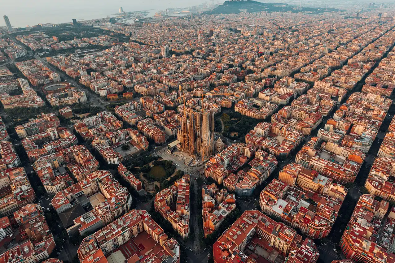
Barcelona has spent a decade trying to give its streets back to the people who live on them. The superblock — a deceptively simple idea that redirects through-traffic away from interior residential streets — has become one of the most discussed urban experiments in the world. But the politics of taking space from cars in a dense, divided, and tourist-saturated city are anything but simple, and the distance between a compelling diagram and a transformed neighbourhood has proved, in places, to be considerable.
On a Tuesday afternoon in the Eixample district, at the intersection of Consell de Cent and Rocafort, something is happening that would have been unimaginable fifteen years ago. Where four lanes of through-traffic once competed for asphalt, a small park has materialized: low wooden benches, drought-adapted plantings in the Catalan dry-garden tradition, a shaded seating area where two older women are playing a board game. Children are cycling in a rough oval around the planted zone, using the former carriageway as a circuit. A delivery cyclist navigates the space slowly, making way for a dog-walker coming the other direction. The noise level is remarkable — or rather, the noise absence is. The traffic din that defines the rest of the Eixample, that rises and falls all day and much of the night, is simply not here.
Walk three blocks in any direction and you are back in the ordinary sonic landscape of one of Europe’s densest neighbourhoods: the rumble of diesel vans, the hydraulic hiss of buses on the main avenues, the compressed roar of motorcycles threading junctions. Barcelona’s Eixample — the rational grid designed by Ildefons Cerdà from 1860, intended with visionary foresight to be a democratic, green, mixed-use city within a city — became, across the twentieth century, one of the most car-saturated residential environments in Europe, its interior streets converted to rat-runs and its chamfered corner lots filled not with the garden courtyards Cerdà originally envisaged but with parked cars, service vehicles, and traffic queuing for the next junction.
The superblock is an attempt to recover something of what Cerdà intended. It is also, in its political life, a case study in the difficulty of recovering it — in why cities know what would make them healthier and more liveable and still struggle, neighbourhood by neighbourhood and election by election, to get there.
The Grid and Its Betrayal
Ildefons Cerdà was a civil engineer who thought like an ecologist before the discipline existed. His 1859 plan for the Eixample — the extension of Barcelona beyond the medieval city walls — was not merely a traffic management scheme or a property development project. It was a social programme embedded in urban form. Each block was to be only partially built up, leaving large interior gardens accessible to residents. Streets would be wide enough for light and air. The grid’s regularity would eliminate the class geography of the old city, where the wealthy lived in upper floors of air and light and the poor in dank basement levels.1 The plan was visionary and, in its essential social ambitions, largely defeated: developers built the courtyard gardens over almost immediately, the facades grew taller than Cerdà intended, and the interior spaces became service yards and eventually car parks.
The twentieth century completed the betrayal. As car ownership in Spain rose sharply from the 1960s under the Franco-era economic boom, the Eixample’s six-lane main avenues and its narrower interior streets were given over to moving and storing vehicles. By the 1990s, the neighbourhood had among the highest concentrations of traffic and the poorest air quality of any residential district in Barcelona. The rooftop terraces, the light-filled chamfered corners, the theoretical interior gardens: these had not produced a city of democratic habitation so much as a city of dense, noisy, polluted proximity.
1859: Cerdà’s Vision
Democratic, green blocks. Wide avenues optimized for light and air, featuring large interior communal courtyard gardens accessible to all residents.
20th-Century Betrayal
Rapid motorization transforms inner streets into car rat-runs. Courtyards are entirely built over or paved for commercial service parking.
The Superblock Model
A 3×3 block perimeter contains heavy traffic. Interior roads switch to shared, low-speed spaces prioritizing active pedestrian life.
Barcelona is also, physically, a city with no slack. Hemmed between the Mediterranean to the south, the Collserola ridge to the northwest, the river Besòs to the northeast and the Llobregat to the southwest, it has no room to sprawl. The metropolitan area contains roughly five million people in a space that forces genuine density, genuine mixing, genuine proximity. That proximity has historically been a cultural and economic virtue and a public health liability simultaneously.
The specific public health liabilities were quantified with increasing precision from the 2000s onwards. Studies commissioned by the Barcelona Public Health Agency found that the city’s residents were exposed to road traffic noise levels above EU-recommended thresholds for the majority of their dwellings — particularly in the Eixample and the older working-class districts of Nou Barris and Sant Andreu.2 Noise, the research confirmed, was not merely an annoyance: it was a measurable driver of cardiovascular disease, sleep disruption, cognitive impairment in children, and excess mortality. Barcelona’s residents were, statistically, dying earlier because of the sound of the streets they lived on. Air quality data told a parallel story: NO2 concentrations from road traffic consistently exceeded EU limit values across large parts of the city, with well-documented associations with respiratory disease, preterm birth, and cognitive development in children.
The Concept: Simple in Theory
The superblock concept was developed by Salvador Rueda, director of the Urban Ecology Agency of Barcelona, across the 1990s and 2000s, and formally proposed as a citywide strategy in 2013.3 Its logic is disarmingly straightforward. Take a three-by-three block unit of the Eixample grid — nine standard city blocks forming a square roughly 400 metres on each side. Designate the perimeter roads of this unit as through-traffic arteries. Designate the interior streets as access-only: no through-traffic, pedestrian and cycling priority, maximum vehicle speed of ten kilometres per hour. The interior becomes, functionally, a shared space: not a pedestrian zone excluding vehicles entirely, but a low-speed, low-traffic environment where children can play, residents can sit, and the acoustic and air quality conditions are substantially improved.
The health mathematics were compelling. The Barcelona Public Health Agency modelled what citywide superblock implementation would mean for public health outcomes and produced figures that were startling in their directness: full implementation of 503 superblocks across the city could prevent approximately 667 premature deaths per year, generate an annual gain of 1.6 years of healthy life expectancy at birth, and produce economic benefits in avoided healthcare costs running to hundreds of millions of euros annually.4 Noise, air quality, and the physical activity effects of streets more conducive to walking and cycling all contributed to the modelled benefit.
The first full superblock pilot was implemented not in the Eixample but in Poblenou — the former industrial district to the northeast, long associated with the city’s manufacturing past and, since the late 1990s, with its digital-economy future.5 In 2016, under Mayor Ada Colau’s newly elected administration, a superblock covering six interior streets was created in a section of Poblenou between Pallars, Bac de Roda, Rambla del Poblenou, and Badajoz. The transformation was rapid and physical: planters, benches, and road markings reconfigured the street space in a matter of weeks. The traffic monitoring that followed confirmed substantial reductions in vehicle movements, noise levels, and NO2 concentrations on the interior streets.
The Politics: Complicated in Practice
The Poblenou superblock also produced something its designers had not fully prepared for: intense and sustained local opposition. Business owners on the interior streets — bars, restaurants, small shops — argued that the reduction in through-traffic had made them invisible, that delivery access had become more complicated, and that customers no longer drove past their shopfronts. Residents who drove cars — a minority, but a vocal one — complained about longer journeys to their own homes. The physical implementation, which was done quickly and with provisional materials rather than full urban redesign, was criticised aesthetically: the planters looked temporary, the line markings faded, and the overall impression was of an intervention that had been applied to the street rather than designed for it.
The political opposition crystallised around the 2019 municipal elections, in which the superblock programme became a significant campaigning issue. The right-wing Partido Popular and the liberal-conservative Ciudadanos both ran against the programme explicitly, framing it as ideological urbanism imposed by the Colau administration on residents who had not been consulted.6 The charge of insufficient participation was not entirely unfair: the Poblenou pilot had been implemented with public consultation that, in retrospect, the administration acknowledged was limited. The participatory planning processes that the city subsequently adopted for later superblocks — longer engagement periods, co-design with local businesses and residents — reflected a lesson learned from Poblenou’s contested implementation.
Colau won re-election in 2019, but without a majority, and the superblock programme proceeded more cautiously in the electoral period that followed. The ambition of 503 superblocks citywide — covering the Eixample entirely — remained official policy in the municipal climate and mobility plans, but actual implementation moved block by block, neighbourhood by neighbourhood, with the political texture of each location shaping the pace and form of each intervention.
The Eixample expansion arrived most visibly with the Superilles Eixample project — the tactical urbanism programme that, from 2021 onwards, began converting one intersection per quarter to a pedestrianised square within the grid.7 The programme, known informally as the “green crosses,” used the Eixample’s chamfered corner junctions — those distinctive octagonal intersections that give the grid its character — as the sites for transformation, converting former traffic lanes to parklets, seating areas, and planted spaces. By 2024, dozens of these intersections had been redesigned. The scale of individual interventions was modest; the cumulative effect on the neighbourhood’s public realm was beginning to be felt.
Evidence: What Has Changed
The evidence from completed superblocks and tactical urbanism interventions is broadly positive on the metrics that the programme was designed to address, though the evidence base is still developing and the full citywide modelling has not been validated against outcomes at scale.
Noise monitoring on interior streets of established superblocks shows reductions that, in the best cases, bring levels below the 55 dB daytime threshold associated with significant health impacts — a reduction that mainstream traffic management cannot achieve without the kind of modal shift the superblock produces.8 Air quality monitoring tells a similar story: NO2 concentrations on interior streets of the Poblenou superblock fell significantly in the years after implementation, though the effect at the perimeter — where displaced traffic concentrates — is more complex and requires careful analysis rather than simple celebration.
The displacement effect is the programme’s most honest methodological challenge. Traffic does not disappear when it is redirected: it moves to the perimeter roads. Whether the net effect on city-wide emissions and noise is positive depends on how many people switch from driving to walking, cycling, or transit when interior streets become less convenient for through-traffic. The evidence suggests that a meaningful proportion of vehicle trips simply do not happen when conditions change — the phenomenon traffic engineers call traffic evaporation — but the magnitude of evaporation varies by location, and the monitoring infrastructure to measure it systematically across the city’s full intervention programme has not always been in place.
Cycling has grown substantially across Barcelona over the past decade, driven by a combination of the superblock programme, the expansion of the cycling network to over 230 kilometres of protected lanes, the introduction of the Bicing public bike-share scheme, and the explosive growth of e-bikes.9 Cycling’s share of daily trips has risen from negligible levels in the mid-2000s to roughly four percent of all journeys in the metropolitan area — a modest figure by Copenhagen or Amsterdam standards but a significant shift for a Mediterranean city whose cycling culture was effectively non-existent twenty years ago. The city regularly ranks among the fastest-growing cycling cities in Europe.
The green crosses have produced something that is harder to quantify but visible in the life of the streets: a different use pattern. Benches and plantings on former road space fill up. Parents bring toddlers to spaces where toddlers could not previously go safely. Elderly residents who had effectively lost the street as a social space, driven indoors by noise and fumes and the absence of anywhere to sit, reappear. The neighbourhood health agency has documented improvements in mental wellbeing indicators in areas of superblock implementation — effects that cannot be attributed to any single change but that reflect the cumulative difference between streets designed for cars and streets designed for people.
Heat: The Dimension That Raises the Stakes
Barcelona’s climate makes the public realm question not merely one of quality of life but of survival. The city sits in a Mediterranean climate that is warming faster than the global average: summer temperatures have risen by roughly 1.4 degrees Celsius since the pre-industrial period, and the frequency of heat events that exceed thirty-five degrees for multiple consecutive days has more than doubled since the 1980s.10 The 2003 European heat wave, which killed an estimated 70,000 people across the continent, was a formative event for Barcelona’s public health and urban planning agencies, and it fundamentally changed how the city thought about the relationship between urban form, temperature, and mortality.
The Eixample’s urban heat island effect is severe. The neighbourhood’s canyon streets — six-storey buildings on both sides, minimal tree canopy, vast expanses of dark asphalt and stone — trap heat with remarkable efficiency. Surface temperatures on a summer afternoon in the Eixample can exceed forty-five degrees Celsius on exposed asphalt. In the interior courtyards and the superblock spaces where tree canopy has been established, temperatures measured at the same time can be five to eight degrees lower.11 That differential is not an aesthetic preference: at forty degrees ambient air temperature, a five-degree reduction in the microclimate around a bus stop or a bench is the difference between a space that is usable and one that is not; at its extreme end, it may be the difference between survival and heat stroke for a vulnerable elderly resident.
Severe urban heat island effect. Six-storey concrete canyons trap radiation, creating perilous microclimates during prolonged heatwaves.
Strategic urban forest shading. Native tree canopies radically lower street-level surface temperatures to vital survival thresholds.
The city’s tree planting programme has accelerated in response. Barcelona’s Urban Forest Plan, adopted in 2017 and updated in 2021, targets the planting of 232,000 new trees in the metropolitan area by 2037, with priority given to the Eixample and the historically under-canopied working-class districts.12 Species selection has shifted away from the ornamental plane trees that line the great avenues — beautiful, drought-tolerant, but allelopathic and of limited ecological value — toward native and near-native species suited to the warming Mediterranean climate: holm oak, carob, olive, strawberry tree, and various Mediterranean pines. The urban forest programme and the superblock programme are, in principle, synergistic: new tree planting in reclaimed road space provides both the cooling and the green cover that both programmes separately justify. In practice, coordination between the two programmes has been uneven, and trees planted in some green cross intersections have struggled due to inadequate soil volumes beneath the paving.
The Tourism Contradiction
Any honest account of Barcelona’s environmental condition must grapple with tourism, because the city’s relationship with mass tourism is simultaneously its most visible political controversy, its most significant driver of displacement, and one of the largest single contributors to its environmental load.
Barcelona received approximately 26 million overnight visitors in 2023, in a city of 1.6 million permanent residents — a ratio that places it among the most tourism-intensive cities in the world relative to resident population.13 The cruise terminals at the port discharge tens of thousands of passengers per day during the summer months, many of them concentrated into the same historic core — the Barri Gòtic, the Barceloneta, the lower Eixample — that the superblock programme is attempting to make liveable for residents. The streets that the programme is quieting for children to play in are, in the height of the summer season, being traversed by tourists on segways, electric bikes, and guided walking tours. The tension between making Barcelona liveable and marketing Barcelona as an experience is not resolved by urban design.
The housing impact of short-term rental platforms — Airbnb and its equivalents — has driven residential displacement from the most desirable neighbourhoods at rates that the superblock programme cannot counteract. The Gràcia neighbourhood, where one of the city’s early small-scale superblock experiments was implemented, has seen the proportion of housing units registered as tourist apartments rise sharply over the same period that the street-level environment was supposedly being improved for residents.14 A neighbourhood made more attractive by greening and noise reduction becomes more attractive to tourists and short-term lettings, raising rents and driving out the residents whose wellbeing the programme was designed to support. The green gentrification dynamic that appeared along the Los Angeles River is present in Barcelona too, operating through the mechanism of tourism rather than simply rising property values — though both are in play.
Mayor Colau, during her administration, made tourist apartment regulation a centrepiece of her housing policy, freezing new licences and pursuing non-compliant operators. The limits of municipal powers — tourist apartment regulation in Catalonia involves overlapping jurisdictions between the city, the Generalitat, and national government — meant that implementation was slower and more contested than the policy intention implied. Her successor, Jaume Collboni, elected in 2023, has continued and in some respects intensified the approach, announcing in 2024 that the city would allow the existing stock of approximately 10,000 tourist apartment licences to expire by 2028 without renewal — a commitment that, if maintained, would substantially reduce the short-term rental market in the city, though legal challenges have immediately followed.
The Unequal City Beneath the Green Urbanism
The superblock programme, for all its genuine merits, has unfolded primarily in the Eixample — one of Barcelona’s most affluent and architecturally prestigious districts. The working-class peripheral districts that form a crescent of denser, less photogenic urbanism around the northern and eastern edges of the city — Nou Barris, Sant Andreu, Sant Martí — have seen less investment in public realm transformation, less tree canopy, and less improvement in the noise and air quality indicators that the programme addresses.
This is partly a sequencing issue: the Eixample’s grid structure makes it particularly amenable to the superblock model, and its high residential density makes the public health benefits per intervention higher. But it is also a political economy: the Eixample has more organised and better-resourced neighbourhood associations, better connections to planning professionals and environmental advocates, and a higher media profile for its interventions. The programme that began in Poblenou — which was undergoing rapid gentrification when the superblock arrived — and expanded into the central Eixample has not reached Nou Barris with the same intensity.
The heat vulnerability data makes the inequality stark. A 2023 study by the Barcelona Public Health Agency mapping heat mortality risk across the city’s neighbourhoods found that the highest mortality risk under extreme heat events was concentrated in the peripheral and working-class districts with the lowest tree cover, the oldest and least insulated housing stock, and the highest proportions of elderly residents living alone.15 These are the same districts that have received the least green infrastructure investment. The cooling benefit of the superblock programme — demonstrably real in the Eixample — has not yet been delivered to the people most likely to die without it.
The air quality story has a similar geometry. The districts with the highest chronic exposure to road traffic pollution are not the Eixample’s interior streets, which are now improving, but the ring roads and arterials of the metropolitan area — the Ronda de Dalt and the Ronda del Litoral, the Gran Via in its passage through the working-class eastern municipalities, the roads serving the port and the logistics zones of the western periphery. These are the routes where traffic displaced from the superblock perimeter roads goes; in some configurations, they are also the routes used by the residents of Sant Boi, l’Hospitalet, Badalona, and the other municipalities of the metropolitan area who do not live in the places where the benefits are being delivered.
The Larger Canvas: The Green Axes and the Metropolitan Challenge
The most ambitious current intervention in Barcelona’s public realm is not a superblock but the Eixample’s Green Axes project — a programme to transform nine of the Eixample’s principal cross-streets into tree-lined pedestrian and cycling boulevards, significantly reducing traffic capacity and creating a network of cooled green corridors across the width of the district.16 The first axis, the Consell de Cent transformation, opened in stages from 2022. By 2025, several axes were in various stages of construction or design, with the full programme expected to create approximately 33 hectares of new green space across the Eixample — the equivalent of more than forty football pitches appearing in the heart of one of Europe’s densest urban fabrics.
The green axes programme is the superblock idea scaled up and made permanent. Where the tactical urbanism of the green crosses used temporary materials, the axes programme involves full urban redesign: new paving, deep tree pits with adequate soil volumes, irrigation systems, underground utilities relocated to accommodate the new trees, street furniture designed for the Mediterranean climate. The construction process has been disruptive — businesses on affected streets have experienced periods of reduced access and trade — and the political management of that disruption has required sustained effort. But the completed sections demonstrate with clarity what Cerdà’s grid can become when it is not organised around the car: generous, shaded, planted corridors that simultaneously cool, quiet, and green the neighbourhood in a single intervention.
The metropolitan scale remains the unresolved challenge. Barcelona proper — 101 square kilometres, 1.6 million people — is surrounded by the Àrea Metropolitana de Barcelona, a conurbation of 36 municipalities covering 636 square kilometres and three and a half million people, governed by the AMB (Metropolitan Area of Barcelona).17 The commuter flows, transport patterns, and environmental pressures of this wider city do not respect the boundary of the municipality. Cars that enter Barcelona from Sant Cugat and Badalona and Cornellà cannot be resolved by street redesign within the city’s limits alone. The low-emission zone (LEZ) that Barcelona operates — one of the most stringent in Spain, restricting older diesel and petrol vehicles from the city’s most polluted areas — has reduced vehicle pollution within its perimeter but has effects that terminate at the municipal boundary.
The extension of the metro and commuter rail network — fundamental to the proposition that residents of the metropolitan area have a genuine alternative to driving into the city — is a matter of Generalitat and central government investment as much as municipal ambition. Barcelona’s local transport authority, ATM, coordinates a network that is well-regarded by European standards but has not grown fast enough to absorb the demand growth of a metropolitan area that has expanded substantially since the network’s core was built. The suburbs built in the 1960s and 1970s — the dense, under-planned towns of Hospitalet, Badalona, Cornellà, Castelldefels — often have poor local transit connections to their nearest rail or metro stations, forcing car use for the first and last mile of a journey that, in its longer section, could be made by public transport.
The Street as Argument
Back on Consell de Cent, in the first completed stretch of the Green Axes, a plane tree planted two years ago is beginning to cast something that might, in a decade, be called shade. The wooden decking around its base, still pale and unstained, has already acquired the informal archaeology of a place being used: a dropped bottle top, a chalk drawing made by a child, the groove in the planking where a bicycle lock has been repeatedly rested. The street is not quiet — this is Barcelona in the afternoon, and no intervention can silence a Mediterranean city entirely. But the quality of the sound is different from the main avenue fifty metres away. It is the sound of people rather than machines.
Barcelona’s superblock programme is real, evidence-based, and producing measurable improvements in the health and habitation conditions of some of the densest urban neighbourhoods in Europe. It is also partial, geographically uneven, contested at every turn, and operating in a city whose tourism economy and housing crisis place structural pressures on liveability that no amount of street redesign can resolve alone. The programme’s greatest achievement may be less the specific interventions than the demonstration effect: the proof that streets can be transformed without the city ending, that residents accept and eventually welcome the change, that health outcomes improve when traffic is removed from residential streets, that the car’s claim on city space is not a law of nature but a political choice that can be politically reversed.
That demonstration matters beyond Barcelona. Every city that is trying to reduce traffic, plant trees, and recover street space from cars faces the same objection: that it cannot be done, that residents will not accept it, that businesses will collapse, that the political cost is too high. Barcelona is a laboratory for the counter-argument. The results of the experiment are not yet complete, and they are not uniformly positive. But enough has changed on enough streets — enough children are cycling in spaces where traffic used to roar, enough elderly residents have recovered access to the outdoor world that noise and pollution took from them — that the argument the programme is making is increasingly hard to dismiss.
Cerdà designed his grid for a democratic city. He intended it to be green, shared, mixed, and lit by Mediterranean light. That it took a century and a half, a public health crisis, a political movement, and a programme of what is sometimes called tactical urbanism to begin recovering his intention is a measure of how completely the car colonised the twentieth-century city. That the recovery is happening at all, block by block, in the face of sustained political opposition and genuine economic disruption, is a measure of what sustained commitment to a simple idea can achieve.
The plane tree on Consell de Cent will take ten years to grow. That is the timescale of urban transformation: longer than election cycles, longer than media attention, longer than the patience of most political actors. The cities that manage it are the ones that make their commitments structural enough to survive the impatience of the interim.
Click to view Endnotes & Technical Sources
- Ildefons Cerdà, Teoría General de la Urbanización (1867). See also: Joan Busquets, Barcelona: The Urban Evolution of a Compact City (Harvard GSD/Actar, 2005); Arturo Soria y Puig (ed.), Cerdà: The Five Bases of the General Theory of Urbanization (Electa, 1999); Manuel de Solà-Morales, Les Formes de Creixement Urbà (UPC, 1993).
- Noise exposure and health data: Barcelona Public Health Agency (Agència de Salut Pública de Barcelona, ASPB). See Mark Nieuwenhuijsen et al., ‘Influence of the Urban Environment on Health: The Urban Environment and Health Initiative’; WHO Environmental Noise Guidelines for the European Region (2018).
- Salvador Rueda, El Urbanismo Ecológico (Agència d’Ecologia Urbana de Barcelona, 2012). Developed for the Plan for Energy, Climate Change and Air Quality of Barcelona (PECQ) 2011–2020 and Urban Mobility Plan 2013–2018.
- Mark Nieuwenhuijsen and Haneen Khreis, ‘Car Free Cities: Pathway to Healthy Urban Living,’ Environment International (2016). Specific citywide estimates from: Natalie Mueller et al., ‘Changing the Urban Design of Cities for Health: The Superblock Model,’ Environment International (2020).
- City of Barcelona, Urban Mobility Service documentation, 2016–2018. See also: Oriol Marquet and Carme Miralles-Guasch, ‘The Superblock Model in Barcelona: An Analysis of Urban Interventions and Mobility Changes,’ in Urban Planning (2022).
- Electoral campaigns and participation critique documented in local press coverage: La Vanguardia, El País Catalunya, and Ara (2019).
- Barcelona City Council, Urban Ecology Department, Eixample Superblocks Tactical Urbanism Report (2022).
- Barcelona urban monitoring network (Sistema d’Informació Urbana). See also: Guillem Vich et al., ‘Green Streets and Their Role in Reducing Urban Noise,’ Cities (2019).
- Barcelona City Council, Mobility Survey data (EMEF); Mobility Plan 2024 progress reports; Catalan Transport Authority data and Bicing system statistics.
- Lelieveld et al., ‘Strongly Increasing Heat Extremes in the Middle East and North Africa,’ Climatic Change (2016); Giorgi, ‘Climate Change Hot-spots,’ Geophysical Research Letters (2006); Servei Meteorològic de Catalunya (Meteocat) data.
- ASPB Environmental Justice Atlas; research on urban heat islands by ICTA-UAB (Institute for Environmental Science and Technology, Autonomous University of Barcelona). See: David Palència et al., ‘Cooling Effects of Urban Green Infrastructure,’ Science of the Total Environment (2021).
- Barcelona City Council, Urban Ecology Department, Barcelona Urban Forest Plan 2017–2037 (Pla del Verd i de la Biodiversitat de Barcelona).
- Ajuntament de Barcelona, Estadística de Turisme (2023 annual report); Institut d’Estadística de Catalunya; Port of Barcelona authority data.
- Barcelona City Council, Departament d’Estadística data on HUT (Habitatge d’Ús Turístic) licenses; investigative series by La Directa and El Periódico.
- ASPB, Vulnerabilitat a les Onades de Calor a Barcelona (2023 report mapping thermal mortality risk limits across peripheral working-class districts).
- Barcelona City Council, Urban Ecology Department, Eixos Verds program documentation (2020–2025). Independent coverage in Metropolis and Urban Land.
- AMB (Àrea Metropolitana de Barcelona) official statistics; governance structure and population statistics across the 36 peripheral municipalities; Institut Metropolità de Barcelona, Pla Director Urbanístic Metropolità (PDU, 2023).


